
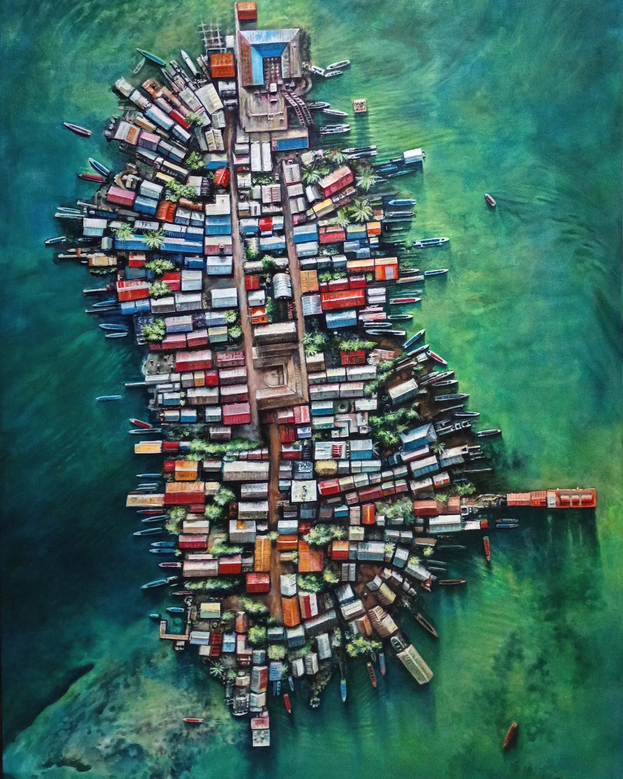


"In Commemoration of Gardi Sugdub, 2024" /Installation at William Turner Gallery, Santa Monica, CA, oil on canvas, 96” x 72”
“In Commemoration of Gardi Sugdub”, concerns the fate of islands in the Panamanian Archipelago, where the landmasses are becoming too flooded and the environs too polluted to sustain the culture. This painting is derived from a reference composite of three drone photos taken from news media. My current project is a series of large-scale oil paintings sourced from images of ecological trauma, captured from the vantage point of drones. I seek to re-examine the role of epic landscape painting, the Sublime and representation, while simultaneously referencing our very real and pressing climate change dilemmas in a series of collaborative projects with artists of different disciplines.
The Project:
Gardi Sugdub is a disappearing island, and its inhabitants are being re-located to the Panamanian mainland in clear-cut jungle cubicles (bottom image). The island is located in San Blas, the autonomous territory of the Gunas, who populated the area after rebelling and fleeing the Panamanian government’s demands that they change their culture.
I would like to address this topic through painting, photography and video, most likely in a collaborative way with artists that have similar topics. One idea in mind is to hire a company to take a high-def satellite photo of Gardi every week, to chronicle its demise (It is already smaller than when I painted it 6 months ago…). This material could be turned into a projection, perhaps with a soundtrack created by a colleague that has visited there and has recorded the music of the Guna (Jacqueline Arias).
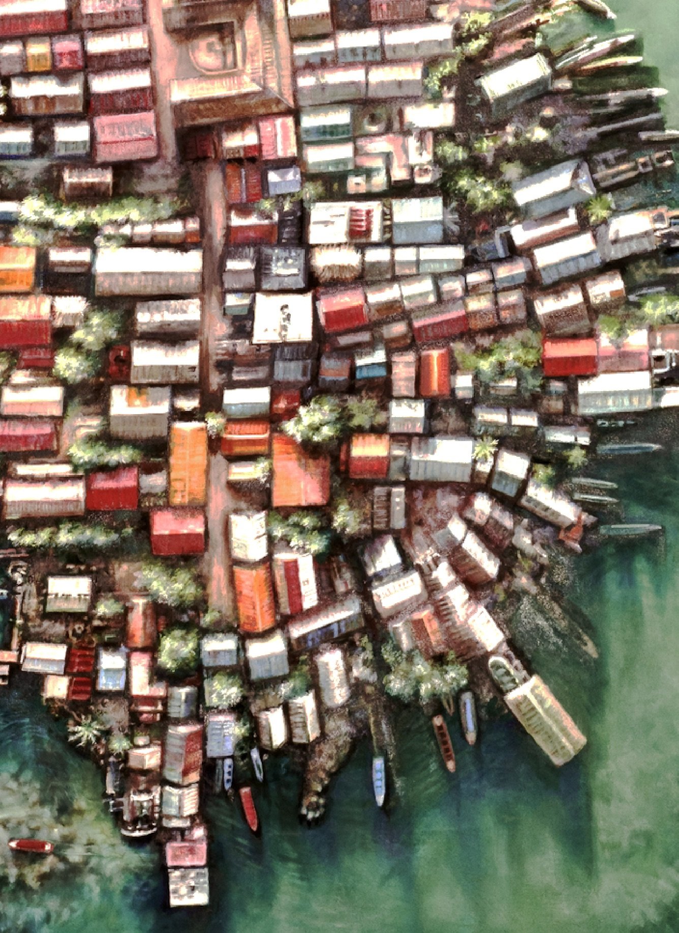
DETAIL:
"In Commemoration of Gardi Sugdub, 2024" oil on canvas 96” x 72”
Each geometric form in the work represents a roof of one of the 300 dwellings covering every square meter of Gardi Sugdub. At top center of the image is the most significant structure, a communal meeting place on the highest ground.
“Since the 1990s, residents on the densely packed island have noticed that their thatched- and tin-roof homes are flooding more and more, especially during the November-to-February rainy season. According to the Smithsonian Tropical Research Institute, the sea around Gardi Sugdub is now rising 3.4mm per year (more than double the rate during the 1960s). Since most of the Guna-inhabited islands lie only 0.5m to 1m above the water, "it is almost certain that all the islands will have to be abandoned by 2100," said Steve Paton, the director of the Institute's oceanographic monitoring programme. “ (BBC, 2023)
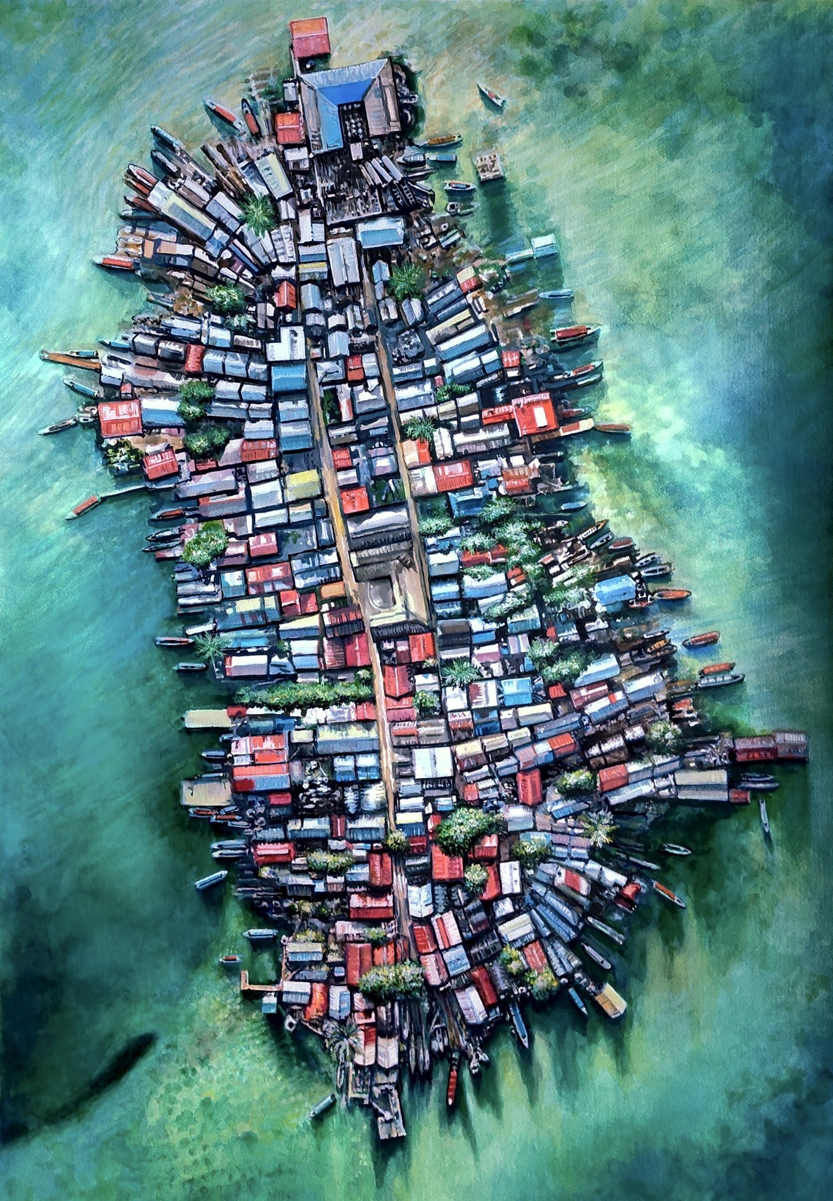
"Study for Gardi Sugdub", 2024, mixed media on Fabiano, 40" x 32"
"Study for Gardi Sugdub" is a multi-media work on paper (gouache, pencil, ink, watercolor), derived from the same drone photos as the larger version.
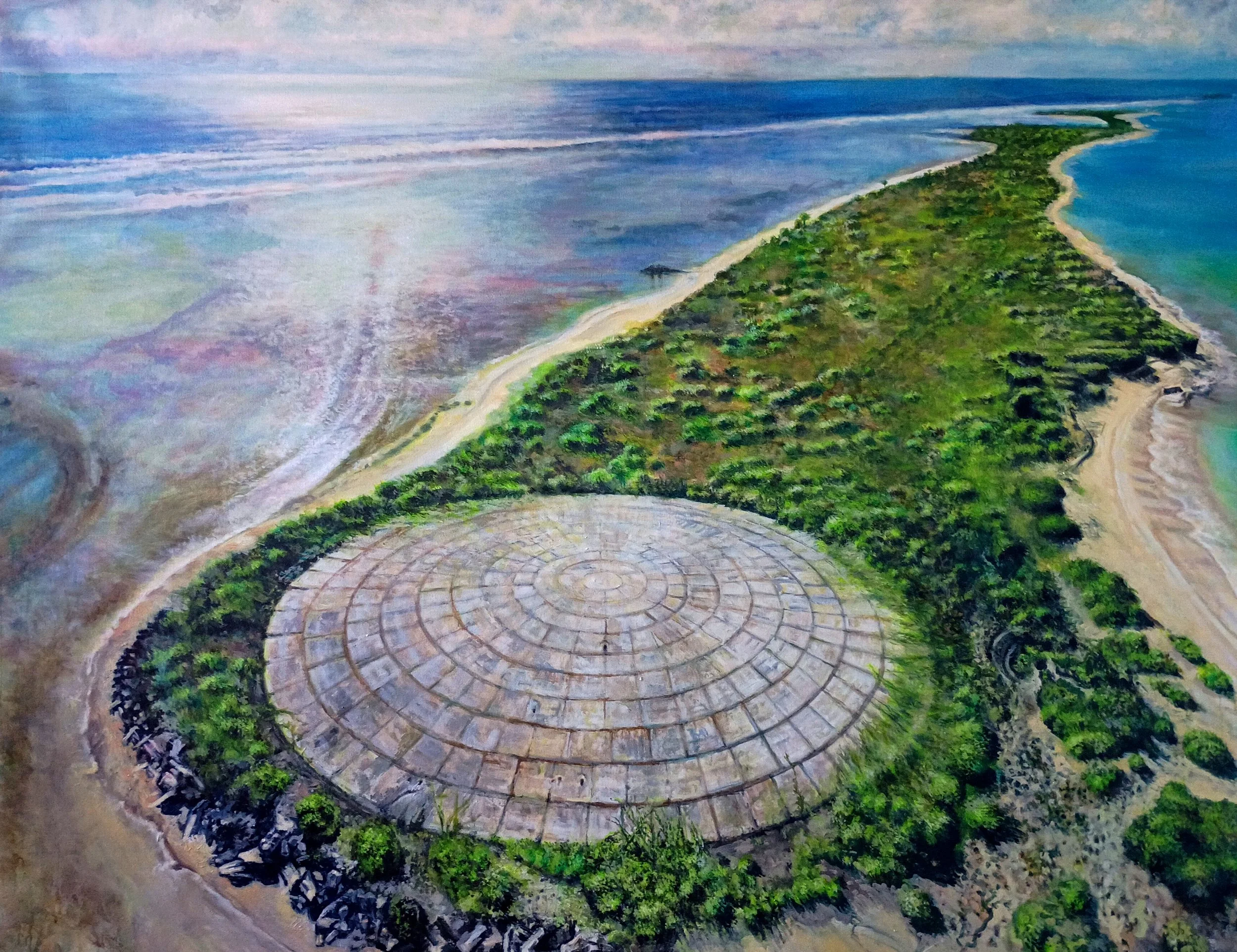
"Runit Dome, Marshall Islands", 2025, oil on canvas, 72" x 96"
"Runit Dome, Marshall Islands" is part of a recent project making “epically-scaled” landscape paintings of traumatized sites.
The Runit Dome was constructed by the US Army Corps of Engineers between 1977 and 1980 in order to contain radioactive waste from America’s Cold War nuclear tests — but it’s begun to crack.
Between 1946 and 1958, the United States detonated 67 nuclear and atmospheric bombs on Enewetak Atoll and Bikini Atoll in the Marshall Islands. Looking to gain an advantage over the Soviet Union in the Cold War, the United States used the island nation as a testing site, dropping not only nuclear bombs, but biological weapons as well. The story of the Runit Dome starts in the 1940s, when the U.S. identified the Marshall Islands as a suitable site for testing nuclear weapons. This calculation, according to The Guardian, was made based on the nation’s low population and distance from other countries and shipping lanes.
In 1946, the United States dropped its first nuclear bomb on the islands. Over the next five years, eight more nuclear bombs — ranging from 23 to 225 kilotons — were detonated near both Enewetak Atoll and Bikini Atoll.
By the 1970s, the U.S. had exhausted its need for testing weapons on the Marshall Islands. Decades of explosions, however, had battered the once edenic landscape, leaving huge craters, destroying entire islands, and, worst of all, leaving behind tons of radioactive waste. The Atomic Energy Commission, (today’s Department of Energy) and the Department of Defense came up with a plan to collect radioactive debris from across the Enewetak Atoll and dump it into the Runit crater, then cover the whole thing with a concrete dome.
For Marshallese, the Runit Dome is a disaster in more ways than one. First of all, it represents the painful history of U.S. nuclear testing. And second of all, it poses a grave danger as the concrete dome begins to age.
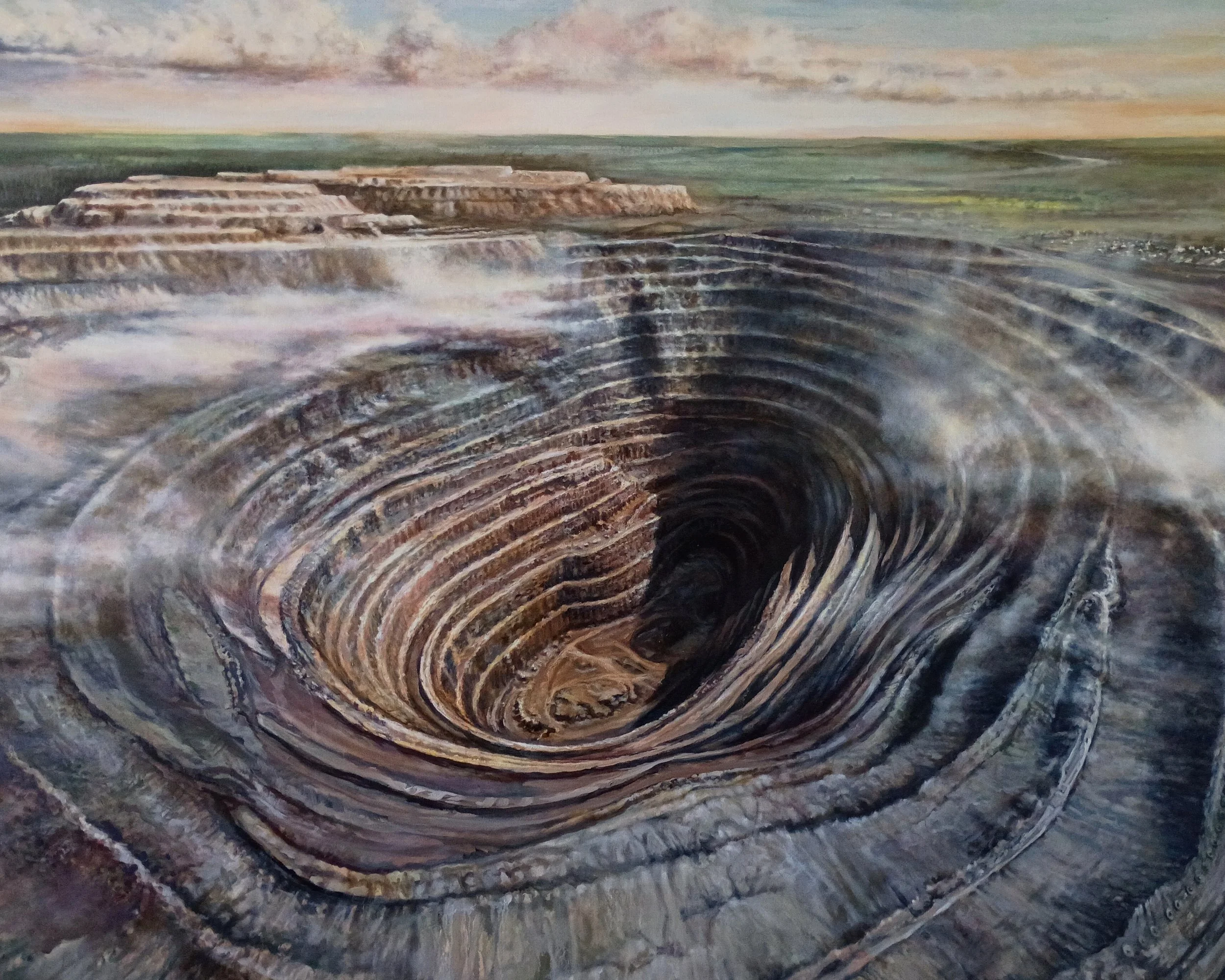
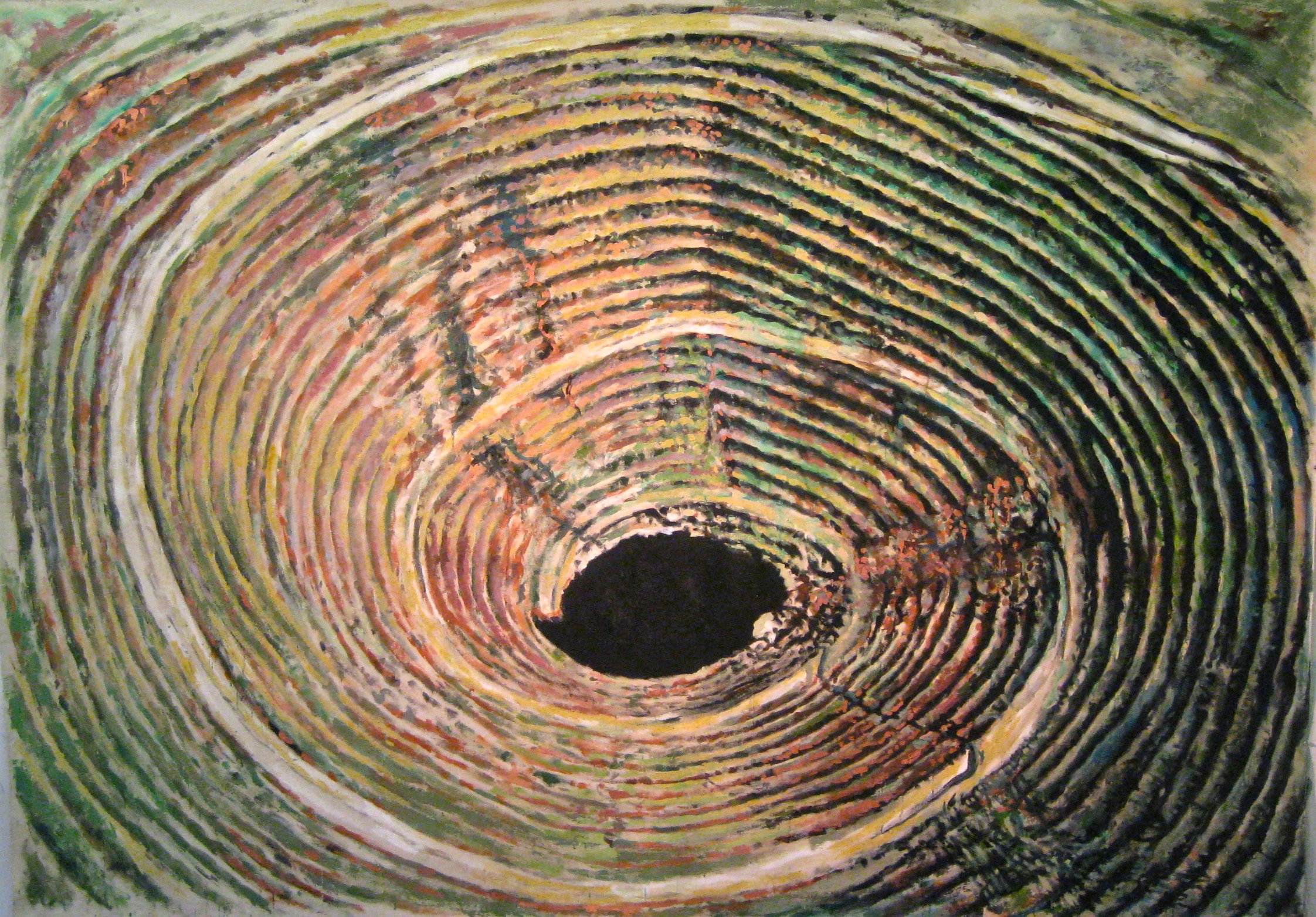
“"Russian Drone Painting 1 (Mir Diamond MIne, 2016)", 2019-2020, oil on canvas, 72” x 96”
The Mir mine, located in Siberia near the town of Mirny, is a massive open-pit diamond mine, the second-largest manmade pit in the world. It's known for its extreme depth (525 meters) and diameter (1200 meters). The mine was a major diamond producer for the Soviet Union and later for Russia, but it's now closed due to safety concerns and flooding.
Due to the strong airflow created by the deep pit, there were incidents of helicopters being sucked downwards, leading to the airspace above the mine being closed to air traffic. In 2017, a major flooding incident resulted in the deaths of eight miners, leading to the mine's permanent closure. The mine is now flooded and abandoned, though mining takes place underground in tunnels below the pit..
"Pripyat, near Chernobyl (Ferris Wheel), 2023", 2024, pencil on Rives BFK, 20" x 29"
The abandoned Pripyat amusement park and Ferris Wheel is located in Pripyat, Ukraine. It was to have its grand opening on 1 May 1986, in time for the May Day celebrations, but these plans were cancelled on 26 April, when the Chernobyl disaster occurred a few kilometers away. Several sources report that the park was opened for a short time on 27 April before the announcement to evacuate the city was made.
"Pripyat, near Chernobyl (Ferris Wheel), 2023", 2024, oil on canvas, 72” x 96”
Most people who visit Chernobyl's Exclusion Zone are interested in seeing the deserted city of Pripyat, a place full of decay. The Ukrainian government is increasingly promoting the zone as a place for “extreme tourism." A short drive away is Chernobyl city, a base for about 3,000 administrators, a handful of scientists and basic accommodations for visitors who choose to spend the night or longer in the zone. To limit radiation exposure, these workers spend 15 days inside the zone, 15 days out.
Pripyat was built on a green field in 1970 and was by all accounts a decent place to live despite the autocratic Soviet rule. It was evacuated 16 years later on April 27, 1986, the day after the accident. After all the people left, Pripyat for years was a snapshot of a planned Soviet town frozen in time: 16-story residential apartment buildings filled with well-preserved posters, toys and stopped clocks; portraits and statues of Vladimir Lenin; A place teeming with embodiments of the hammer and sickle, the symbol of Soviet power.
Spreepark or Spreeland is a former amusement park located in the north of the Plänterwald locality, in the Berlin district Treptow-Köpenick.
The once thriving park was renowned for drawing in big crowds each year but today it remains a shadow of its former self that’s fallen to a state of total disrepair.
First opening in 1969 as East Germany’s only consistently-operating amusement park, it grew in popularity to the point that in the 1990s it was welcoming a total of 1.5 million visitors each year.
Yet, its popularity didn't last and in the following years Spreepark saw the number of visitors crossing its gates decreasing. In 2001, the company administrating the park - Spreepark Berlin GmbH - said it was insolvent. The following year, the ground didn't open its doors to guests, and has since become a ghost town with wild animals and urban explorers being its only visitors these days.